Global Science Report is a weekly feature from the Center for the Study of Science, where we highlight one or two important new items in the scientific literature or the popular media. For broader and more technical perspectives, consult our monthly “Current Wisdom.”
The press has been quick to jump on the idea that post-tropical cyclone Sandy (it was not a hurricane at landfall) was worsened by anthropogenic global warming and that “superstorms” are here to stay.
But I must ask the impertinent question: could anthropogenic global warming actually have lessened the impacts of Sandy?
There are basically three pro-global warming talking points involving Sandy: 1) global warming has caused sea levels to rise, thus making the storm surge larger, 2) global warming has led to higher sea surface temperatures and thus stronger hurricanes, and 3) global warming is making extratropical circulation features more conducive to intense and slower moving storm systems.
There is precious little evidence to definitively support any of these points when applied to Sandy, and, in fact, there exists a body of evidence pointing to the opposite conclusion—that anthropogenic global warming may have actually acted to mitigate the intensity of Sandy. Perhaps what lies closest to our current best understanding is that anthropogenic global warming made little contribution one way or the other.
Let’s start with sea level rise. Water levels at New York City’s Battery Park location have been measured and recorded since 1856. The full record shows an overall (relatively steady) rise of about 0.11 inches per year, for a total rise between 1856 and now of just a bit more than 17 inches. How much of this has to do with anthropogenic global warming? Maybe a third, or about 6 inches. Of the rest, about half was caused by a subsidence of the land (geological processes related to the end of the last ice age, see Engelhart et al., 2009 for example), and the remainder to a warming up from the naturally occurring cold period which ended in the mid-19th century. So of the total 17.34 feet of water (above the station datum) recorded at The Battery tide gauge during the height of Sandy, about 0.5 feet of that could probably be linked to anthropogenic global warming. This is not nothing, but the overwhelming majority of the damage done by the storm surge would have happened anyway. For comparison, the influence of the full moon that night was about as large as the influence of anthropogenic global warming.
As to anthropogenic global warming’s impact on the path, frequency, and intensity of hurricanes, there is a mixed bag of potential outcomes which may be detectable far in the future (towards the end of the century) if anthropogenic greenhouse gas emissions continue to rise. The current science suggests that the frequency of hurricanes could decrease, the intensity may increase slightly, and the preferred path may be displaced out to sea (Wang et al., 2010). The net effect on the U.S. is anyone’s guess at this point (but 2 of the 3 argue for fewer hurricane impacts in the U.S.). But what virtually everyone does agree upon is that any influence of anthropogenic global warming on hurricane characteristics is not detectable in today’s climate (see for example, Knutson et al., 2010). So that talking point is basically off the table.
Which brings us to the third global-warming-made-Sandy-worse talking point—the influence of anthropogenic global warming on the extratropical circulation characteristics.
This is where the rubber really meets the road when it comes to Sandy’s behavior. Without the northward, and ultimately westward pull from the upper atmospheric jet stream, Sandy would have progressed harmlessly eastward, away from the Northeast coast, and out to sea. But that is not what happened. Instead, a fairly deep trough (southward excursion) of the jet stream was coincidentally passing through the eastern U.S. just as hurricane Sandy was progressing up (but offshore) the U.S. Eastern Seaboard. This trough had the effect of attracting Sandy, and drawing it northwestward, pumping energy into it, and changing its character from a hurricane to an extra/post tropical storm system (also known as a Nor’easter in this part of the country). In October, this type of behavior is not particularly unusual. The preferred tropical cyclone track maps provided by the National Hurricane Center (Figure 1) indicate a general tendency for tropical cyclones in October to curve back into the northeastern U.S.—just like Sandy did.
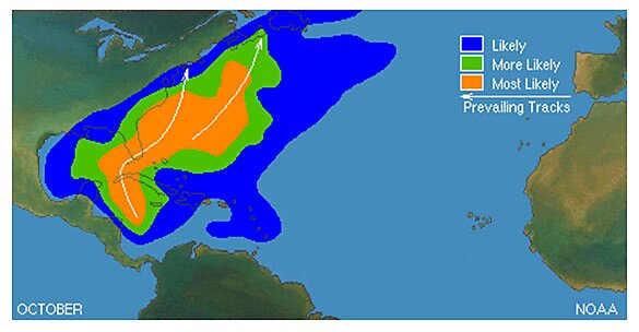
Figure 1. Prevailing tropical cyclone tracks for the month of October (source: National Hurricane Center, http://www.nhc.noaa.gov/climo/)
In fact, since the beginning of the 20th century, there have been about a dozen or so tropical cyclones that have made landfall in the U.S. north of Cape Hatteras which had a westerly component to their trajectory either immediately before or just after they came ashore. This includes historically damaging storms such as the 1903 New Jersey hurricane, the 1938 Long Island Express hurricane, and 1972’s Hurricane Agnes which is still the flood of record in many parts of the Northeast.
The last one was tropical storm Danielle, over twenty years ago. This is the longest interval in the record (since 1900) between westward-component storms north of Hatteras. So much for the influence of global warming!
So, given this fairly typical behavior—why would anyone even consider that anthropogenic global warming played a role in Sandy?
For two reasons: 1) any bad weather these days is immediately linked to global warming by someone with an agenda, and 2) there was a paper published last spring (Francis and Vavrus, 2012) in which the authors concluded that the decline of Arctic sea ice (tied to anthropogenic global warming) was causing the Arctic to warm up faster than the lower latitudes, reducing the natural north-south temperature gradient which is where the jet stream (and extratropical storms) gain energy. According to Francis and Vavrus, a less energetic jet stream contracts and becomes more meandering, with relatively deeper troughs and higher ridges which produce slower moving storm systems and more extreme weather.
Since Sandy was strengthened and pulled ashore by a deep trough/ridge system in the jet stream, folks are quick to assume that the Francis and Vavrus mechanism tying in anthropogenic global warming must be involved.
Not so fast!
This is like claiming to have made a new discovery that, when flipping a coin, heads are now more likely to occur than tails. And wouldn’t you know, the next time the coin is flipped, it came up heads—to which you proclaim, “See, I told you so.” And since heads are associated with a bad outcome, the press flock to your explanation. But what is completely overlooked, is that other researchers have examined every coin flip for the past 60 years and found that heads and tails occur with equal likelihood. So the current heads outcome is simply part of the natural 50–50 occurrence of heads or tails.
In this case, the other researchers are a pair of atmospheric scientists from Cornell University which have examined the forward speed of all nor’easters along the East Coast from 1951 through 2006 (Bernhardt and DeGaetano, 2012). And what they found, in their own words, was “There was no clear trend in [nor’easter forward] speed during the time period, although considerable season-to-season variability was present.” In other words, while there is a lot of storm-to-storm and season-to-season variability, there is no overall trend towards slower moving nor’easters (Figure 2)—so much for the Francis and Vavrus hypothesis.
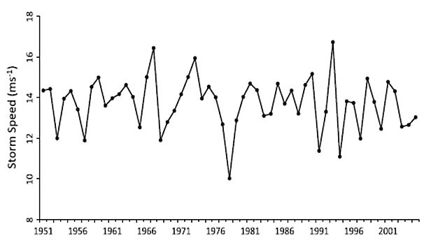
Figure 2. Average speed of East Coast winter storms (nor’easters), from 1951–2006 (source: Bernhardt and DeGaetano, 2012).
And, there has been a lot of other research on changes in the patterns and characteristics of the Northern Hemisphere jet stream during the period of anthropogenic global warming which did not find that same thing that Francis and Vavrus found (we detailed many of these findings in our March 8, 2012 Current Wisdom). At least one of those papers suggested that the methodology employed by Francis and Vavrus “can generate false, or mask actual, variability patterns including trends” (Strong and Davis, 2007). Others concluded that global warming contracted, the jet stream, flattened it over the eastern U.S., and sped it up a bit—characteristics, which, along with a decreased temperature gradient, if applied to Sandy, would have combined to produce a less intense post tropical storm system than if global warming had not been occurring.
So rather than anthropogenic global warming making Sandy worse, it could have actually lessened its intensity and impacts.
The truth is, is that it is impossible to know how, or even if, global warming played any role at all in the lifecycle of Sandy. The science is all over the map, and the signal-to-noise ratio is so low that no matter what is occurring its impact in any direction is undetectable.
But it is sexier and has much more press appeal to proclaim that the destruction wrought by “superstorm” Sandy is the product of our unrestrained fossil fuel consumption, rather than the equally plausible opposite—that anthropogenic climate changes may have combined to lessen Sandy’s intensity.
References:
Bernhardt, J.E., and A.T. DeGaetano, 2012. Meteorological factors affecting the speed of movement and related impacts of extratropical cyclones along the U.S. east coast. Natural Hazards, 61, 1463–1472, doi:10.1007/s11069-011‑0078‑0
Engelhart, S.E., et al., 2009. Spatial variability of late Holocene and 20th century sea-level rise along the Atlantic coast of the Unites States. Geology, 37, 1115–1118.
Francis, J., and S. Vavrus, 2012. Evidence linking arctic amplification to extreme weather in mid-latitudes. Geophysical Research Letters, 39, L06801, doi:10.1029/2012GL051000.
Knutson, T. R., et al., 2010. Tropical cyclones and climate change. Nature Geoscience, 3, 157–163, doi: 10.1038/ngeo779
Strong, C., and R. Davis, 2007. Winter jet stream trends over the Northern Hemisphere. Quarterly Journal of the Royal Meteorological Society, 133, 2109–2115, doi:10.1002/qj.171
Wang, C., et al., 2011: Impact of the Atlantic warm pool on United States landfalling hurricanes. Geophysical Research Letters, 38, L19702, doi:10.1029/2011GL049265.
