In April, Cato’s Patrick Eddington introduced his new online initiative Checkpoint America: Monitoring the Constitution-Free Zone. Americans who live in or travel through the so-called “border zone” can be subjected to motor vehicle stops and constitutionally dubious searches at internal checkpoints run by U.S. Customs and Border Protection (CBP). But some of these “border” checkpoints are located as much as 100 miles inside the country — and stories of abuse of citizens’ rights by CBP agents at these sites are rampant. Meanwhile, the government has stonewalled efforts to increase transparency over their practices at these checkpoints — a 2015 Freedom of Information Act request to CBP filed by Eddington for information on these checkpoints, including the length of motorist stops for “secondary” inspections and the number of use-of-force incidents, has been on administrative appeal for two years.
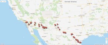
The interactive map at Cato’s Checkpoint America displays the location of “border” checkpoints, along with accounts of abuses that have occurred there, court proceedings involving a given checkpoint, and more.
Eddington’s Checkpoint America features an interactive map where you can view the location of individual checkpoints; see overhead and ground-level photography of the facilities; find physical descriptions of the checkpoints; and read (where available) press accounts, administrative actions, and court proceedings involving a given checkpoint.
“CBP agents operating these checkpoints routinely violate the constitutional rights of citizens and others who are forced to pass through them to get to work, go to the store, or make it to a vacation destination in the American Southwest,” wrote Eddington. “The need for this project, and for greater scrutiny of these checkpoints, is more pressing than ever.”
View the map and read more about Eddington’s research on abuse at the border at cato.org/checkpoint-america.
